Domain selection
Humath selects the simulation domain: Europe / MACC domain or Mexico pilot box.
LUWA integrates satellite observations, atmospheric transport modelling and lightweight emission-estimation methods. The workflow combines TROPOMI-based products, meteorological data, data assimilation and LOTOS-EUROS simulations to support source-level environmental analysis.
Integration of observations and model outputs to improve the representation of atmospheric composition, transport and source influence.
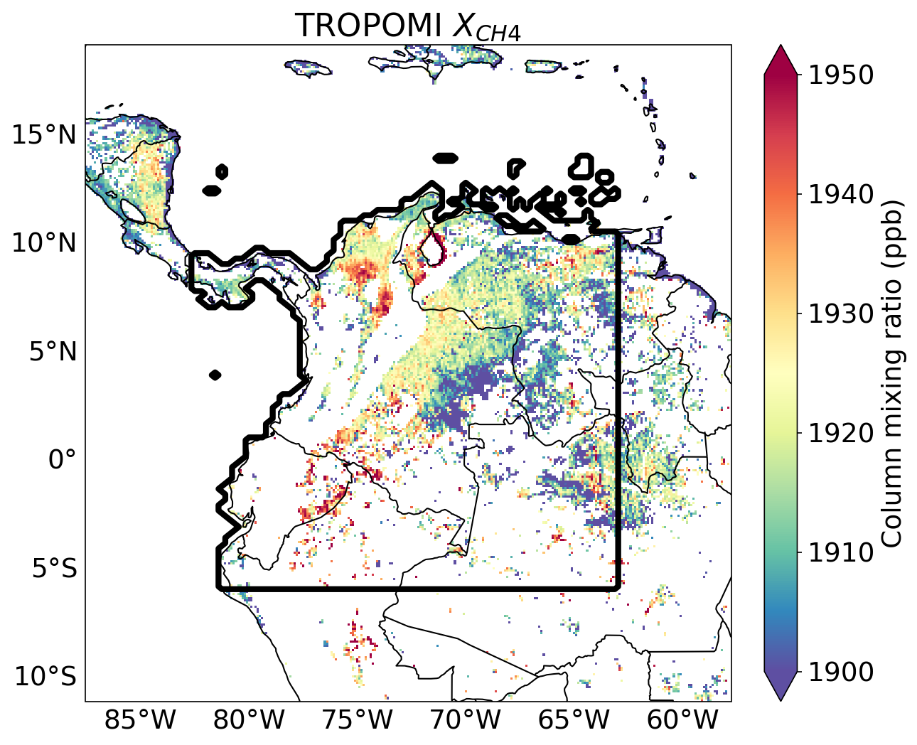
Use of satellite products, including TROPOMI-based observations, to detect spatial patterns of NO2, SO2, NH3 and related atmospheric signals.
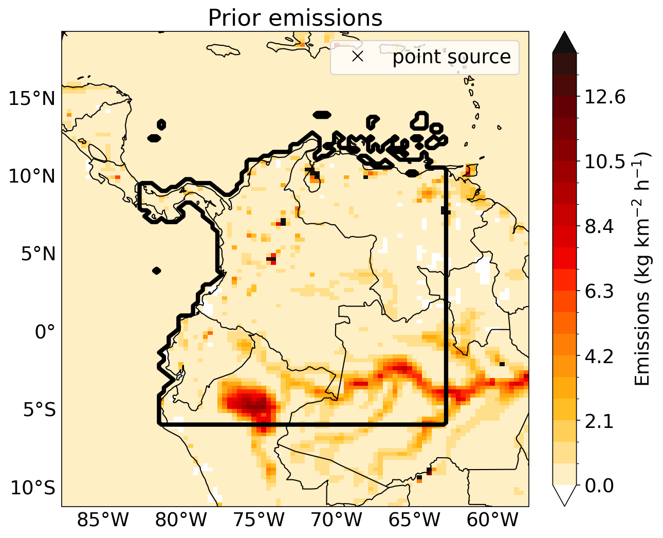
Application of lightweight methods and inverse-modelling concepts to estimate emissions from point sources, industrial areas and agricultural systems.
Atmospheric chemistry-transport simulations using LOTOS-EUROS workflows deployed in cloud infrastructure for controlled environmental scenarios.
Analysis of plume direction, dispersion, source attribution and meteorological drivers using satellite data and wind fields.
Configuration of simulation domain size, grid resolution, simulation period and output cadence for cloud-based atmospheric modelling experiments.
This section explains the simulation workflow from the client request to the delivered products. Humath provides the domain, grid resolution, species of interest, output type and output cadence, then sends the simulation request. LOTOS-EUROS uses meteorology, emissions, boundary conditions, land cover and surface data as model inputs, computes atmospheric transport, chemistry and deposition, and returns structured outputs through LUWA. For both available domains, the output grid is configurable up to 1 km grid spacing. The input datasets have their own native spatial resolution and temporal variability; they are documented and mapped to the selected model grid for each run.
Humath selects the simulation domain: Europe / MACC domain or Mexico pilot box.
Humath selects the grid resolution, simulation dates and output cadence: hourly or 3-hourly.
Humath selects the pollutants and diagnostics required for the client: gases, aerosols, deposition or plume products.
Humath selects the output format and sends the simulation request. LUWA returns files, maps, summaries or API-ready layers.
Domain, resolution, simulation period, species of interest, output type and output cadence.
Meteorology, emissions, boundaries, land cover, topography, soil, sea mask, fires and chemistry settings.
Concentration fields, deposition fields, maps, NetCDF/CSV/GeoJSON products, QA/QC summaries and API-ready datasets.
Simulation window: 2024-08-12 to 2024-08-22.
Simulation window: 2024-07-01 to 2024-07-27.
How to read this table: this is a single LOTOS-EUROS input → output table. It keeps the verified URLs inside the table, together with the native input resolution, temporal variability, model output and Humath request/use. The configured LOTOS-EUROS output grid remains selectable up to 1 km in both available domains.
| Simulation component | LOTOS-EUROS input | Native input resolution / variability | Reference URL / where to check | LOTOS-EUROS output | Humath request / use | Europe / MACC 2024-08-12 to 2024-08-22 |
Mexico pilot box 2024-07-01 to 2024-07-27 |
|---|---|---|---|---|---|---|---|
| Run configuration | Humath request: domain, simulation dates, grid resolution, species of interest, output type, output cadence and active modules. | Configured output grid: selectable up to 1 km for both available domains. Output cadence can be hourly or 3-hourly. LOTOS-EUROS may use shorter internal time steps for numerical stability. | TNO LOTOS-EUROS model page https://airqualitymodeling.tno.nl/lotos-euros/ | Executable LOTOS-EUROS run package with domain metadata, grid definition, output schedule, logs and reproducible configuration record. | Humath defines the simulation request before launch and receives structured outputs for dashboard, report or API integration. | MACC domain, 2024-08-12 to 2024-08-22. Preset grid: 0.50° × 0.25°, 100 × 140 cells; high-resolution output option up to 1 km. | Mexico pilot box, 2024-07-01 to 2024-07-27. Provided box: 24.0°N to 23.0°N, 103.0°W to 102.0°W; selectable output grid up to 1 km. |
| Meteorology |
ECMWF meteorological fields: pressure, temperature, U/V wind, specific humidity, cloud cover, cloud liquid/ice water, orography, land/sea mask, soil type, boundary-layer height, 10 m wind, 2 m temperature and dewpoint, sensible and latent heat fluxes, friction velocity, solar radiation, precipitation, snow, sea-surface temperature, sea ice and soil water.
Technical roleThese fields drive advection, vertical mixing, cloud processing, wet removal, dry deposition, plume transport and chemistry. |
ERA5 single-level data: commonly available at 0.25° × 0.25° and hourly temporal resolution. Meteorological inputs are mapped to the selected LOTOS-EUROS grid and vertical structure. | ERA5 single-level meteorology https://cds.climate.copernicus.eu/datasets/reanalysis-era5-single-levels LOTOS-EUROS model reference https://airqualitymodeling.tno.nl/lotos-euros/ | Weather-driven transport diagnostics: plume movement, mixing depth, rain/cloud diagnostics, stability, wind fields and meteorological context for each output time step. | Explains why pollution moves in a given direction, why it accumulates, and when rain or mixing reduces concentrations. | ECMWF/CAMS-compatible meteorology clipped or interpolated to the MACC domain. | Global ECMWF/CAMS-compatible meteorology clipped or interpolated to the Mexico pilot box. |
| Derived meteorology |
Raw meteorology converted by LOTOS-EUROS into model-ready quantities.
Derived fieldsGrid-level altitudes, layer thickness, cell volume, air mass, air density, 3D volume fluxes, relative humidity, total rain, in-cloud and below-cloud coverage, rain intensity, soil moisture index, gravimetric soil water, friction velocity, stability parameters and vertical diffusion coefficient. |
Derived on the selected LOTOS-EUROS grid. Variability follows the meteorological input frequency and the model internal time stepping. | LOTOS-EUROS model reference https://airqualitymodeling.tno.nl/lotos-euros/ | Physical diagnostics used internally and available for interpretation: air density, vertical diffusion, rain intensity, cloud diagnostics and transport fluxes. | Supports technical interpretation of uncertainty: transport, mixing and deposition can be linked to the meteorological state of the run. | Derived internally for the MACC grid. | Derived internally for the Mexico grid. |
| Boundary and initial conditions |
CAMS global products, MACC products, climatologies, EMEP monthly fields, TM5 simulations or parent LOTOS-EUROS simulations.
Boundary meaningBoundary conditions provide concentrations entering through the west, east, south, north and top of the domain. Initial conditions define the starting atmospheric state. |
CAMS global forecasts: global atmospheric-composition products with product-specific grid and output frequency. CAMS EAC4 reanalysis: 0.75° × 0.75° and 3-hourly, useful for historical composition context. | CAMS global atmospheric composition forecasts https://ads.atmosphere.copernicus.eu/datasets/cams-global-atmospheric-composition-forecasts CAMS global reanalysis EAC4 https://ads.atmosphere.copernicus.eu/datasets/cams-global-reanalysis-eac4 | Background concentration fields for gases and aerosols, separated from emissions generated inside the selected domain. | Helps distinguish local or regional source influence from pollution transported into the domain. | CAMS/MACC boundary conditions for reactive gases and aerosols are the standard option. | CAMS global boundary conditions are the practical default; exact product/version is fixed in the run package. |
| Anthropogenic emissions |
Human-source emissions from public power, industry, combustion, fossil-fuel extraction, solvents, road transport, other mobile sources, waste and agriculture.
Proper sector names
|
Dataset-dependent. European CAMS/TNO inventories provide high-resolution gridded emissions and point sources. EDGAR provides global gridded emissions at 0.1° × 0.1°, with yearly, monthly and up to hourly products. | CAMS anthropogenic and natural emissions https://atmosphere.copernicus.eu/anthropogenic-and-natural-emissions EDGAR global emissions https://edgar.jrc.ec.europa.eu/ CAMS-REG-v4 scientific reference https://essd.copernicus.org/articles/14/491/2022/ | Gridded and point-source emissions by pollutant, sector, time step and vertical allocation; sector totals and source-attribution-ready input layers. | Shows which sectors enter the simulation and supports source-level interpretation for clients. | TNO-MACCIII / TNO-CAMS European emissions, including area emissions and point sources. | Mexico inventory to be selected and converted to LOTOS-EUROS format; global or national inventory can be mapped to the same model structure. |
| Emission speciation and timing |
Bulk emissions for NOx, SOx, NMVOC, CH4, NH3, CO, PM2.5 and PM10-2.5, plus sector-specific temporal profiles.
Technical mappingNOx is split into NO and NO2; SOx into SO2 and sulfate aerosol; NMVOC is mapped to CBM-IV species; PM is split into EC, OC/POM, sulfate aerosol, sodium and remaining primary particulate matter. |
Annual inventory values are converted into model-time emissions using monthly, weekday/weekend and hourly temporal profiles. Some profiles can vary dynamically with meteorology, such as heating demand or cold-start effects. | LOTOS-EUROS model reference https://airqualitymodeling.tno.nl/lotos-euros/ CAMS emissions documentation page https://atmosphere.copernicus.eu/anthropogenic-and-natural-emissions | Hourly or 3-hourly model-ready emissions mapped to LOTOS-EUROS tracers and chemistry mechanisms. | Turns inventories into chemical-model inputs that can produce pollutant concentrations, aerosol components and deposition. | MACC/TNO-CAMS chemical split and time profiles. | Mexico emissions require species mapping and temporal profiles before launch. |
| Land cover, topography and surface |
CORINE/Smiatek, CORINE 2018, Global Land Cover 2000, land-sea mask, soil type, topography and roughness tables.
Proper land-use namesLOTOS-EUROS land-use classes include urban areas, agriculture, grassland, deciduous forest, coniferous forest, mixed forest, water, marsh/wetland, sand/bare rocks, tundra, permanent ice, tropical forest and woodland shrub. DEPAC classes include grass, arable land, permanent crops, coniferous forest, deciduous forest, water, urban, other and desert. |
CORINE 2018: 100 m raster product with 25 ha minimum mapping unit. Global Land Cover 2000: global land-cover support, commonly used outside Europe and translated into LOTOS-EUROS / DEPAC classes. | CORINE Land Cover 2018 https://land.copernicus.eu/en/products/corine-land-cover/clc2018 Global Land Cover 2000 / JRC https://forobs.jrc.ec.europa.eu/products/glc2000/products.php LOTOS-EUROS model reference https://airqualitymodeling.tno.nl/lotos-euros/ | Surface parameter fields: land-use fractions, DEPAC classes, roughness length, deposition surfaces, coastline treatment, inland-water mask and soil/topography context. | Explains why deposition, biogenic emissions, dust and coastal effects differ by location. | CORINE/Smiatek with optional CORINE 2018 enhancement. | Global Land Cover 2000 or equivalent global land-cover product translated to LOTOS-EUROS / DEPAC classes. |
| Biogenic emissions |
Vegetation, temperature, photosynthetically active radiation, leaf area index and plant functional types.
Proper module names
|
LOTOS-EUROS documentation describes MEGAN input maps at 150 seconds (1/24°) for its implementation. Biogenic emissions vary with temperature, radiation, LAI and canopy activity. | MEGAN data and code https://bai.ess.uci.edu/megan/data-and-code/megan21 LOTOS-EUROS model reference https://airqualitymodeling.tno.nl/lotos-euros/ | Biogenic VOC emission fields, especially isoprene and monoterpenes, used for ozone and secondary organic aerosol formation. | Separates vegetation-driven chemistry from industrial, urban or transport-driven pollution. | European tree-species database where available; MEGAN can be selected depending on setup. | MEGAN v2.04 is the practical default for non-European vegetation emissions. |
| Natural aerosol and soil sources |
Soil NO, sea-salt generation, natural dust, traffic resuspension and agricultural land-management dust.
Proper formulation names
|
Computed on the selected model grid from land cover, soil texture, soil water, snow cover, roughness length and wind speed. Variability follows the meteorology and surface state. | LOTOS-EUROS model reference https://airqualitymodeling.tno.nl/lotos-euros/ | Natural-emission layers: soil NO, sea salt, wind-blown dust, road dust and agricultural dust as time-dependent input fields. | Helps identify non-industrial contributions to PM, NOx background and coastal aerosol loading. | Sea salt, soil NO, dust, traffic resuspension and agricultural dust activated according to the experiment design. | Dust and sea salt may be relevant depending on local terrain, coastline exposure and July meteorology. |
| Fire emissions |
CAMS-GFAS fire emissions and, where applicable, SILAM / IS4FIRES information on injection height.
Fire variablesDaily fire emissions, plume-bottom height, mean altitude of maximum injection, plume-top height and species mapping into LOTOS-EUROS tracers. |
CAMS-GFAS: global fire-emission product at 0.1° × 0.1° with daily mean fire-emission information. Injection-height variables are used where available. | CAMS-GFAS fire emissions https://ads.atmosphere.copernicus.eu/datasets/cams-global-fire-emissions-gfas | Fire-influenced tracer fields and smoke-related emissions that can be included in the concentration simulation or reported as contextual influence. | Avoids confusing smoke episodes with industrial, transport or urban emissions during the selected period. | Screen CAMS-GFAS activity for the August 2024 MACC-domain period. | Screen CAMS-GFAS activity for July 2024 over the Mexico pilot box. |
| Chemistry and aerosols |
CBM-IV oxidant chemistry, ISORROPIA2 or EQSAM aerosol equilibrium, primary aerosol settings and optional VBS secondary organic aerosol.
Model speciesTypical outputs include NO, NO2, O3, SO2, sulfate, nitrate, ammonium, NH3, HNO3, CO, VOC-related tracers, PM2.5, PM10-2.5, EC, POM, sea salt and dust, depending on selected modules. |
Chemistry is calculated on the configured LOTOS-EUROS grid, up to 1 km output spacing where selected. Chemical processes follow the model time step and output is written hourly or 3-hourly. | LOTOS-EUROS model reference https://airqualitymodeling.tno.nl/lotos-euros/ | Concentration maps and time series for gases and aerosols, plus chemically produced secondary species. | Provides the main air-quality products Humath can expose to clients through dashboards, reports or API layers. | Standard LOTOS-EUROS chemistry package for the MACC run. | Same chemistry package once emissions and boundaries are mapped to LOTOS-EUROS tracers. |
| Deposition and removal |
DEPAC gas dry deposition, Zhang particle dry deposition, aerodynamic resistance, vegetation resistance, soil resistance and wet scavenging.
Wet-removal namesLOTOS-EUROS supports in-cloud and below-cloud scavenging following a CAMx/Banzhaf-style approach, including cloud-water and pH-dependent wet removal. |
Computed on the selected output grid using meteorology, land-cover fractions, roughness, vegetation state, cloud and precipitation fields. Variability follows surface and weather conditions. | LOTOS-EUROS model reference https://airqualitymodeling.tno.nl/lotos-euros/ | Dry deposition, wet deposition and atmospheric loss fields for selected gases and particles. | Supports environmental-impact interpretation: where pollutants are transported, where they deposit and how rain removes them. | Computed from European land cover, meteorology and chemistry. | Computed from Mexico land cover, meteorology and chemistry. |
| Delivery layer | Completed LOTOS-EUROS outputs, metadata, logs and selected post-processing rules. | Output files use the configured LOTOS-EUROS grid, up to 1 km, and the selected cadence: hourly or 3-hourly. | LOTOS-EUROS model reference https://airqualitymodeling.tno.nl/lotos-euros/ | NetCDF model fields, CSV summaries, GeoJSON-ready layers, maps, time series, plume diagnostics, source context, QA/QC report and API-ready products. | Humath can integrate the outputs into a client-facing SaaS experience after the simulation request is completed. | Hourly or 3-hourly output package for the Europe / MACC run. | Hourly or 3-hourly output package for the Mexico pilot box. |
| Run QA/QC | Input coverage, missing hours, units, coordinates, domain overlap, vertical levels, tracer availability, inventory year, time-zone profiles, restart/spin-up status and logs. | QA/QC reports the native resolution and temporal coverage of every input layer, plus the configured output resolution and cadence. | TNO LOTOS-EUROS model page https://airqualitymodeling.tno.nl/lotos-euros/ | Run-control report with file completeness, configuration traceability, output integrity and known limitations. | Gives Humath a technical basis for presenting results to clients and deciding whether a run is ready for external delivery. | QA/QC for all MACC-domain files between 2024-08-12 and 2024-08-22. | QA/QC for all Mexico-domain files between 2024-07-01 and 2024-07-27. |